Introducing Remote Sensing
Remote Sensing is a technique to obtain information about the properties of an object without physically contacting it from a distance. In contrast to field-based measurement, remote sensing offer advantages in terms of time, cost, and also energy efficiency. It allows for the coverage of larger areas and is more effective compared to field-based measurement.
Remote sensing involves several steps, including planning the mission and choosing the suitable sensors, receiving and recording the signal data, and the analyzing the resultant data.
Satellites used in remote sensing do not directly measure the Earth's geophysical parameters. Instead, satellites will observe, capture and measure solar and terrestrial radiance (light) present in a vertical column of the atmosphere. These radiance measurements are then converted into geophysical parameters through the application of science-based algorithms (physics, assumptions and so on).
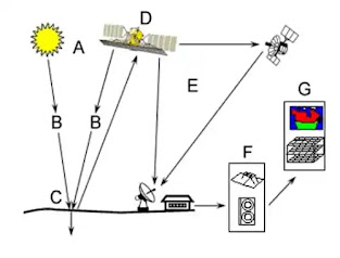
There are seven process components of remote sensing:
(A) Energy Source or illumination
(B) Radiation and the Atmosphere
(C) Interaction with the target
(D) Recording of Energy by the Sensor
(E) Transmission, Reception and Processing
(F) Interpretation and Analysis
(G) Application
Spatial resolution refers to the number of pixels used to construct an image. To get a higher spatial resolution, a smaller pixel size is needed to capture images with more detailed information. However, larger storage capacity is needed to store the image details.
Spectral resolution refers to the sensor's ability to distinguish between different wavelength intervals in the electromagnetic spectrum, represented by bands. Higher spectral resolution can be achieved by detecting more small-width bands, resulting in a higher level of detail in the information captured by the images.
Temporal resolution refers to the amount of time needed to revisit and acquire data for the exact location. A high temporal resolution enables the observation and analysis of rapid changes that occur over short time intervals, providing a more precise understanding of temporal dynamics.
There are three types of remote sensing: aerial photography, multispectral and active and passive microwave.
More details on remote sensing will be introduced in the next post.
However, remote sensing has a wide range of applications across various fields.
- Watershed Management
- Water Resources Mapping
- Water Conservation and Rainwater Harvesting
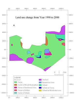
- Land use/land cover classification
- Water Quality Monitoring
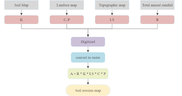
- Land Degradation
- Groundwater Potential Zonation
- Tsunami and Earthquakes
- Flood mapping
- Extreme Heat
.png)


Comments
Post a Comment