Digital Image Analysis
Prior to the analysis of remote sensing systems, they undergo a pre-processing stage. However, the radiation received by satellite sensors is subject to various phenomena that introduce radiometric and geometric distortions. As a result, two types of correction are required: atmospheric correction and geometric correction.
During the atmospheric correction, the light detected by the satellite sensor differs from the light reflected by objects on the Earth's surface. The radiation reaching the sensor, known as reflectance, is influenced by the presence of the atmosphere. In contrast, the unaltered radiation is referred to as radiance. To accurately interpret the characteristics of the Earth's surface, it is necessary to eliminate the atmospheric influence and obtain the true reflectance values.
Geometric correction is a crucial step in image acquisition to address distortions that can result in significant disparities between the actual Earth coordinates and the corresponding image coordinates. The primary technique employed for geometric correction is image transformation, where the pixels in a distorted raster image are rearranged. This involves comparing the distorted image to a geometrically accurate reference image or map using control points, which are easily identifiable features like intersecting roads or edges. These control points are evenly distributed in both the distorted and reference images. Subsequently, a function is used to relocate the pixels in the distorted image, aligning them with the coordinate system of the reference image.
After the preprocessing stage, various types of analysis can be performed on remote sensing data, including visual image interpretation, classification, and change detection. Visual image interpretation can be structured into three stages: identifying general areas (e.g., settlements, tree-covered areas, open spaces, water bodies), identifying similar areas (e.g., fields, grassland, specialty crops, mixed areas), and examining individual objects (e.g., plant species, fallow land, vegetation density). This analysis considers factors such as object size, shape, position, contrast, and color saturation. Indirect visual analysis can also provide insights into the height of objects.
Image classification is necessary to group small areas with similar reflection values into larger classes. This process helps to emphasize relevant information while disregarding less important details. For example, streams and rivers can be grouped into a "water" class, while residential areas and parking lots can be classified as "built-up" areas. Classification can be performed in a pixel-oriented or object-oriented manner. Two main types of classification methods are unsupervised classification and supervised classification.
The unsupervised classification relies solely on statistical techniques and is conducted by a computer. It serves as a foundation for unbiased analysis of patterns and structures. On the other hand, supervised classification involves the user or an image analyst overseeing the pixel classification process. The user defines the spectral signatures or pixel values associated with each class by selecting representative sample sites known as training sites or areas.
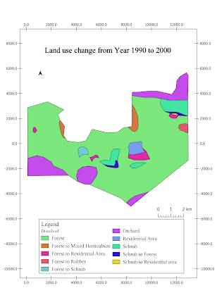
Change detection is a method used to examine alterations between satellite images captured at two distinct time periods. The modifications observed in these multi-temporal satellite images can be evaluated using different approaches, such as image algebra and post-classification change detection.
.png)


Comments
Post a Comment